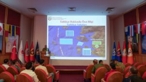
Ankara University National Research Center for Maritime Law (DEHUKAM) coordinated registration of Turkish Maritime Spatial Planning (MSP) at IOC-UNESCO (Intergovernmental Oceanographic Commission). The plan is open for international access at the international body’s online MSPGlobal platform. The move disturbed neighboring Greece, which claims jurisdiction in territorial waters across the Aegean Sea. The issue is a longstanding source of hostilities between the two countries, which nowadays pursue rapprochement.
MSP is crucial for Türkiye’s sustainable use of territorial waters and international recognition. DEHUKAM Director Mustafa Başkara told Anadolu Agency (AA) on Tuesday that the MSP, first publicized in April, was part of efforts for the “Blue Homeland,” Türkiye’s ambitions and goals to protect its territorial waters. “This is a milestone and will contribute to subsequent efforts,” he said.
Greece has protested the plan that designated zones for specific activities in the Aegean Sea of the Eastern Mediterranean, accusing Ankara of attempting to claim areas of Greek jurisdiction in a move without legal grounds. Maritime spatial plans define where activities, including fishing, sea transport, tourism, aquaculture and renewable energy projects, can take place.
In April, Greece submitted its own maritime spatial plan to the EU, citing geopolitical issues in the Eastern Mediterranean, among other issues, for the delay, which had drawn rebuke from the European Commission.
Türkiye said in April its map was prepared in line with the European Union’s rights, obligations and laws and the United Nations Convention on the Law of the Sea (UNCLOS).
Greece called on Türkiye to end its claims and warned that it would take “appropriate action in all international fora.”
A separate Greek plan for a marine park in the Aegean Sea has irked Ankara, which has said it would not accept a possible “fait accompli on geographical features whose status is disputed.”
A high-level meeting between Greece and Türkiye, part of an established mechanism to discuss differences, is expected to take place in Türkiye.
Başkara says Greece’s statements have “no effect on the validity of this map or its existence, nor would it affect Türkiye’s ambition to reclaim its territorial waters. Türkiye certified a map it has been advocating since the 1970s, a map based on international laws and complying with legal claims,” he said.
The two countries came close to an all-out war in the 1990s over the Aegean Sea, and they still remain vigilant, with Türkiye concentrating on developing a domestic defense industry. Greece relies on foreign partners to boost its defenses. An agreement on where their maritime zones begin and end is important for determining rights over possible gas reserves and power infrastructure schemes. Türkiye, which has the longest continental coastline in the Eastern Mediterranean, rejects the maritime boundary claims of Greece and the Greek Cypriot administration, arguing that their excessive claims violate the sovereign rights of both Türkiye and the Turkish Cypriots.


Be First to Comment